theirwork: community mapmaking turns guerrilla activity
In paper-based and computer workshops co-developers jointly discussed their codes (tags), sharing their ideas of place on and offline.
Loe Pool, Cornwall's largest natural lake in the Southwest of England, has become a sacred place for a group of local residents, who have recently been mapping out their concept of environment. theirwork, an online experiment by designers Dominica Williamson and Emmet Connolly, demonstrates that the future of ecology is a local affair.
The concept
The online community mapping process is a social, non-commercial enterprise based on one location - Loe Pool, a small freshwater lake suffering from the effects of pollution. To date about eighteen local residents have been involved as co-mappers, but the prototype experiment is open to everyone, so anyone can add to the map (whether resident or transient visitor). The co-mappers, who become co-developers, have been using the lake environment in a number of ways, over a period of time - walking or running around the lake for leisure and pleasure, riding their bikes, fishing, drawing, picnicking, working. As participants in theirwork they assisted in the first stage of the process by walking, talking and recording their experiences, feelings, and sensory impressions, indicating why they were of interest to them. This provided the basis for marking places on the map. Data taken from the experience of spending time onsite or in the 'real' location provided the building blocks from which to construct the virtual location. Now that the surface map is ready, others can join in and add to it. The nature of the web-based interface allows anybody to access the project online when pointed to or when stumbled across. What is more, the interface allows rummaging, meandering, editing and adding to the map-based content.
The background
theirwork derived from a global movement called Green Map System. GMS promotes an eco-cultural way of making maps and is an organisation driven by 'action and responsibility'. It encourages people at a local level, from any background and from anywhere in the world, to form teams of all ages. Together such teams chart the natural and cultural environments that exist in their streets, parks, rivers and other localities. Working together, these mapmakers gather data, develop designs for maps and finance map productions. The result is, 'regionally flavoured maps that fulfil local needs, yet are globally connected' in almost fifty countries. There are over 350 projects and over 250 published maps. The maps are globally recognised and connected because they use the same set of global icons - a Green Map system of shared visual language. The aim is to help people live a better, more sustainable way of life. Teams are increasingly creating online versions of such maps. Many of these are static web pages. Instead of a closed finite map, the theirwork designers wanted to provide an empty map where people could deposit information when online, allowing an ongoing, interactive development.
theirwork draws on themes from a number of movements, such as Green Mapmaking, sustainability, Open Source, folksonomy, phenomenology and qualitative research.
In addition, theirwork wanted to create a map that was easier to maintain and easier to change than a printed or static web map. An up-dateable web map also enabled the creation of a snapshot history of a locale. In addition, creating the right atmosphere online allows the content-caretakers to listen to people as they use the map and as they start archiving data. They can watch and track how the map is used, its efficiency and the impact it is having. It becomes possible to find out whether the map triggers such positive effects as, for example, residents looking after a location better or at the very least, having raised awareness about it.
David Abram's 'The Spell of the Sensuous' inspired the designers' research and philosophy. Abrams calls for a re-habitation of place and body so that people can start inhabiting places like coastal forests and grasslands again. To do this, he says, requires action. And this action is successful when bioregional communities develop a language that is representative of the local 'soundscape' (prevalent sounds found in a particular space). A phenomenological approach was supported and reinforced by this angle of enquiry, and then re-introduced through an ethnographic, as well as a Green Map process of data collection and analysis. The participants were invited to take part in the project before it existed online. Before they typed, they walked, talked, drew and shared ideas. This approach meant that map-making and the power/knowledge that results from the act of creating a map could reach more people, and help more people 'connect' to their place. theirwork's aim was increasingly to facilitate a more empowering understanding of the term sustainability. Bioregional mapping empowers individuals within their localities and gives them a clearer comprehension of sustainable ideas. From this position, theirwork has developed an innovative framework to help explore, de-centre, and re-frame the concept of 'sustainability', to generate new meanings and practices.
Liberation through adherence to ‘Openness’
Reflecting all the time and with purpose, theirwork attempts to set an example of project-based sustainable activity, using a sustainable vehicle delivering sustainable data. To meet this maxim it was fundamental to adopt an Open Source method of production (and licensing), in which key ideas are re-use, shared licensing and open content - these are computer software programmes where the source code is made available to anyone who may wish to study it and make derivative versions of it. This is in contrast to the usual computer software systems that exclude, restrict and prohibit derivative versions. The above prohibitive way of working is creating large virtual data piles that can only be altered, customised and improved by the exclusive few who have created the code or have access to the code. This can be related to other ways of digital working. For instance, too many images that can't be re-used (due to copyright restrictions) are also leading to image-mountains. This type of digital material presence is yet another source of waste production. With theirwork (or a future, fully-fledged version of theirwork grown out of its infancy), one can learn things about a place, store information and then move on to the next place. One can keep walking and learning, working and sharing, as the source code and content is licensed so that others can access, use or change it, resulting in less data to be (re) made. The mantra reduce, reuse, recycle is fully incorporated here.
This way of thinking - future thinking or rather re-thinking is vitally important because until very recently much sustainability practice has been bound up in research-based institutes in the form of academic research or within mainstream government-based funding schemes. The scopes of these organisations has often been highly limited because they have frequently been too stretched or pre-occupied with the usual way of working, embodying standard computer systems, and are not simply motivated and educated enough to apply such practice-based sustainability at the ground level and on a day-to-day basis. theirwork, as an Open Source mapping example, is reaching towards "sustainable software", implementing a green digital working practice or simply put, a greener way of working with software
In the context of theirwork, the implications of using sustainable software on a day-to-day and long-term project basis are still emerging. Crucially there is an "open" approach to planning and building the project. This openness means more than simply Open Source software licensing. It is the openness to allow the project to naturally find its own path to success; to avoid being overly deterministic, even dictatorial in the planning of a project, and to be instead open to new ideas, letting the project evolve and take its own direction, allowing access to anyone who wishes to get involved or move the project in a new direction.
Over time unexpected, but worthwhile results will emerge, results that would be impossible if a project was subject to the strict restraints of commercial software development. By working outside the confines of profit-driven commercial systems and outside set and established standards the mapping activity operates in a guerrilla-like way, exploiting the freedom to roam on a journey of discovery. These ideas are derived from the software world where Open Source software, allows anyone to adapt it to their own needs – basically do with it as they please. There is a rich ecosystem of software development that has grown out of this area, and there are many examples of successful software projects that could never have happened, or been sustainable, without this model to support it. Linux operating systems, one of the only challenges to the virtual commercial monopoly held by Microsoft with their Windows Operating System, is one example of this. This model, applied quite comfortably to software development here, can easily be applied to other models of production or organisation as well.
Political and philosophical directions influenced even the most technical aspects of the development of the project. The use of licensed mapping software (such as Google's online mapping technology) was rejected in favour of a more open approach. Instead, bespoke software for representing and interacting with the on-screen map was developed. Thankfully, some Open Source programming toolkits were accessible that helped greatly in creating the software and meant that this intimidating task did not have to be undertaken from scratch. The work made available by others was used -and built upon to realise the project's unique vision - without compromising.
Another brick in the sustainability wall is that of Open Data. Ordnance Survey licensing issues are an excellent example of the bad and ugly counterpart of Open Data. By contrast, making data open, accessible and free encourages people to get involved without having to fear that their contribution will disappear into a black hole. By sharing the material that all of us can contribute, and by putting it into the public domain, widespread engagement is facilitated and encouraged, the quality of the material improves exponentially, opening up excess spare time for new developments. Growth potential – the much-hyped buzzword in business parlance – takes on real meaning.
The building blocks
Roaming
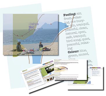
To achieve the degree of openness and communal co-development that enables co-mappers to participate in steering the concept of the project, it was important to let them 'roam free' after delivering an induction to the process in a first focus session. The co-mappers then revisited the lake as part of the theirwork project, aiming to make the 'world into a home', re-experiencing the importance of the place through texture, silence and sound, image and emotional experiences. The act of walking and recording walks became an important area for each co-mapper. The 'type of walk' each co-mapper liked to do became an integral part of data collection and data analysis. The co-mappers were helped in tracking the walks; sites of interest, favourite places, memory spots, stories connected to a place, objects, plants and animals were noted using cameras, notebooks, a GPS unit and Dictaphone.
Tracking
The co-mappers were involved in creating the base map of the lake as well as in the creation of the content for the base map. To do this theirwork walked around the perimeter of the Cornish lake with a GPS unit (Global Positioning System), recording track points of the path, taking photos for reference and subsequently transferring this data to a computer. At any stage, this base map can be reviewed and changed by co-mappers. They have now become co-developers. Currently the only way to mark a place on the map is by way of entering a geocode (a latitude and longitude figure), rather than just dropping the place of interest onto the map - over time the goal is to change and improve this, because the core idea is to let people add data of personal relevance, to tell others why they feel the place is important, in short to share their innermost feelings about their locale. In time, snapshots of history can be built up as people add their photographs or drawings, and eventually sound may also emanate from the map or its markings. Continuous change as an inherent element of theirwork based on user-interactivity makes online-mapping a site of user empowerment, by the user for the user.
Coding
To help collect, translate, share and code the data, a loose framework of qualitative enquiry was developed based on Douglas Ezzy's multi-disciplinary approach. He believes multidisciplinary approaches to qualitative research are integral to good ethnography and theirwork was influenced by his way of working with conversation and text. theirwork introduced co-developers to qualitative coding methods as a way of creating open collaboration that was down to earth and easy to relate to. The framework used open and closed questions. Answers to open questions, such as "What do you feel about the lake?" were geo-tagged. Adhering to Ezzy's recommendation of a participatory-grounded ethnographic approach to data collection, theirwork fitted into each co-developer's agenda.
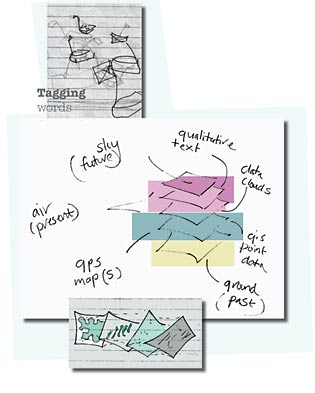
To capture the essence of informal walks – like was it a sunny, cloudy, windy or rainy day? Dictaphone recordings were transcribed. Some of the codes that developed from the walks were words such as rocks, water, agriculture, birds, meditation, trees, fields, memories, fish, events. They originate from sentences by eight different people, referring to their direct interests around the lake. In a paper-based workshop co-developers then jointly discussed the codes, shared their record of the walk from memory and grouped their memories into shared title codes. Importantly, qualitative data became coded by the co-developers, not by some distant and 'removed' ethnographer.
Tagging
The next step and an important part in the puzzle of mapmaking is how to categorise the collected data. In fact, with the coding that had taken place categorisation had already started to take place. Tags were ready-made for the map interface. A starter kit had been created, which effectively introduced the co-developers to tagging or folksonomy. Folksonomy is an internet-based information-retrieval methodology. It aims to make a body of information easier to search, discover, and navigate over time. A well-developed folksonomy becomes a shared vocabulary that is originated by, and familiar to its users.
Using this folksonomic approach theirwork tackled the question of what a sustainable model of group data classification actually is? Green Maps have encountered this problem. Setting criteria for what should appear on a map immediately amounts to editorial control. If this control is strong, it results in the exclusion of data that some people feel is important, and counters the idea of openness. If free reign is permitted, the end result may lack structure and may collapse into chaos. theirwork was keen to give co-developers as much personal choice in terms of content as possible without jeopardising a final map that would still show a coherent picture. This involved discarding any notions of hierarchical classification, and instead allowing co-developers to tag their data with keywords to describe it instead. A data point has many keywords pinned onto it instead of just being placed into a single category. This actually opens up the process significantly and leads to a much more creative way of adding data. Users now have the freedom to use the map in ways that may never have been thought of in the first place – one of theirwork's major goals.
Computing
Workshops have played an important part in the process, from the introductory focus session through to the paper workshop, which set the stage for a computer workshop. The computer workshop tested the beta software framework. Co-mappers were by then able to teach each other how to use the software framework. They put marks on the map using latitude and longitude figures supplied from the archive of their walks. They tagged their marks efficiently and with ease, having been introduced to the concept of folksonomy in the paper workshop.
The theirwork designers listened carefully to co-developers views, feelings and ideas for the future of the software. When things started taking shape onscreen the mood in the workshop room was electrifying: everyone suddenly watched their places appear on the map and all the efforts and concepts that must at times have seemed utterly puzzling started to make sense. Meeting the designer Emmet on web-cam, as he fixed technical problems from Dublin, was another exciting moment. Everyone in the room was totally thrilled when tags suddenly got bigger than others – realising the connection of frequency of use, when others shared their tag. More workshops and more walks were requested – theirwork co-developers had caught the mapping bug.
The future
Far from being content with daytime mapping, already full moon walks have taken place - creating, recording and archiving night-time words and night-time drawings. In addition to the recording of every day walks and conversations, co-developers also requested specialist events. The first butterfly foray has taken place, and bat and moth parties and sea-mapping events are in the pipeline.
The theirwork designers regard this as testimony of the project's success so far, and in the name of 'sustainability' more paper and computer workshops are being planned. A resource workshop is under development. This will introduce co-mappers to a number of tools such as RSS feeds, flickr functions, book marking libraries and forum functions (feed://theirwork.org/blog/feed > http://flickr.com/photos/theirwork/sets > http://del.icio.us/theirwork > http://theirwork.org/forum)
Establishing a counterforce to commonly established protocols and thinking on a small-scale local level, is success in itself. Enhancing a somewhat taken-for-granted experience of local landscape through developing a shared consciousness of one's closest surroundings is an added bonus. What gives the greatest satisfaction is to see community activity turning guerrilla activity and achieving sustainable results quite apart from the pleasure of seeing participants' enjoyment in the mapping process, which has given them a heightened awareness of their locality. They now see the old environment with new eyes.
What is important here is that the mapmaking process continues (is sustainable) and is grounded in multiple perspectives. Multiple voices and autonomous experiences are documented via first person sensory experience and through a community's felt experience of landscape. theirwork is not just about walking around and making a map, it is about a collective digital notebook or diary - a storage box and a place of reflection. In a sense theirwork is about giving room for place in varying ways, so that it can become valued and brought into a shared consciousness. Encouraging actual bodies to walk, talk and record experiences in real-time space is creating a highly personalised, visual, kinaesthetic, emotional, sensory and tactile copyright-free bioregional map. The question now is how sustainable is it to grow and roam the project elsewhere?
Project Details
Map:
http://theirwork.org
Blog:
http://theirwork.org/blog
Links
Green Map:
http://greenmap.org
Green Atlas: http://greenatlas.org
Loe Pool: http://en.wikipedia.org/wiki/Loe_Pool
Open Source: http://www.opensource.org
Authors
Emmet Connolly is an interaction designer living in Dublin. Dominica Williamson is a freelance artist and designer working in the field of digital design and sustainability and is based in Cornwall.
Contact
dom@theirwork.org
emmet@theirwork.org
The theirwork designers would like to thank all the co-developers who have been involved in the project so far, and to those who supported early R&D, and to all those in Green Map System.